Wegener's Continental Drift
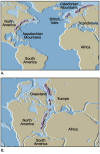
- Wegener first noticed the similarities in the shoreline of continent on
both sides of the Atlantic Ocean. He particularly liked the way in which
South America and Africa fit. It was
not until the 1960's that scientists proposed a new map using the edges of
the continental shelves as the true boundaries of the continents.
- Wegener used documented cases of fossil organisms that had been found on
different landmass that could not have crossed the current oceans.
- Fossils of Mesosaurus (a reptile) have been found only in
South America and Africa.
- A certain variety of garden snail is found only in the western part of
Europe and the eastern part of North America.
- Wegener also discovered matching mountain
ranges on each side of the Atlantic Ocean.
- The Appalachian Mountains
that disappear off the coast of Newfoundland match mountains in the British
Isles and Scandinavia which are comparable in age and structure.
- The Cape Mountain Range in southern Africa have similar geologic
structure and rock composition as the Sierra Range near Buenos Aires.
- The Hebrides Mountains in northern Scotland match up with similar
formations in Labrador.
- The Caledonian Mountains in Norway and Sweden match up with the Canadian
Appalachians.
- The last form of evidence that Wegener use to support his continental
drift hypothesis was ancient climates. When the continents are put together
to form Pangaea, the remains of glacial materials
fit together to form a pattern like the large ice sheets that cover our
poles today.
- By the 1960's, there had been many technological discoveries that would
aid in the revision of the continental drift hypothesis that would turn it
into the plate tectonic theory. In this theory, the earth is made up of many
sections of lithosphere, solid pieces of the earth's crust and upper mantle,
that float on top of a plastic-like layer under the lithosphere known as the
asthenosphere. Each of these pieces of lithosphere is called plate.


Layers and composition
- The Earth consists of several layers with
distinct properties: crust, mantle, and core.
- The outermost crust is essentially a shell of rock. Its thickness varies
from around 35 km under the continents and 5 km under the oceans.
- The layer below the crust is the mantle. The mantle is denser due to a
higher composition of iron and magnesium. The Earth's thin crust and the
uppermost portion of the mantle make up a relatively cool and rigid layer
about 100 km thick, known as the lithosphere.
- Below the lithosphere, the mantle is warm and partially molten in
places; it supplies the magma for volcanic eruptions. Deeper in the mantle,
higher pressures force the rock into the solid phase despite even higher
temperatures. But even in solid form, the mantle slowly flows, and
convection continually carries heat up
from below.
- The rocky lithosphere is brittle and is broken into the thick, moving
slabs of rock called tectonic plates. The
movement of the plates results in various geological activities, such as
volcanism and earthquakes.
- With increasing depth, the temperature rises and the mantle gradually
becomes more pliable. Rock here is hot enough to fold, stretch, compress,
and flow very slowly without fracturing, somewhat like Silly Putty. This
'plastic' layer is known as the asthenosphere. The tectonic
plates, made up of the relatively light, rigid rock of the lithosphere,
actually ‘float’ on the more dense, flowing asthenosphere.
- The boundary between the lithosphere and the underlying asthenosphere is
defined by a difference in response to stress: the lithosphere remains rigid
for very long periods of geologic time in which it deforms elastically and
through brittle failure, while the asthenosphere deforms viscously and
accommodates strain through plastic deformation.
- Under the mantle lies a metallic core. The outer region
of the core is molten, but high pressures in the inner core force the metal
into solid form.

Tectonic plates
- ***Tectonic activity is in part fueled by the energy that comes from the
original heat from the days when the Earth was still molten. In addition,
radioactive decay of heavy elements inside the Earth adds to this heat.
- The Earth's internal heat is thought to drive
convection similar that that which occurs
in a saucepan filled with hot water. Hot
rock rises slowly from deep inside the earth, cools, flows sideways and
sinks. The rising hot rocks and sideways flow are thought to be the factors
that control the positions of ocean basins and continents, which means that
convection determines the shape of the Earth's surface.
- Thus, the Earth has all the ingredients needed for exciting geology: a
hot interior to supply energy for volcanism, convection to help generate
tectonic stresses, and a relatively thin lithosphere that does not inhibit
geological activity.


Types of deformation
- A fault is a fracture surface along which motion has taken place.
Movement along faults usually takes place as a series of small, sudden
displacements, with intervals of years or centuries between successive
jerks.
- Folding takes place by slow, continuous movement, in contrast the
jerky motion along faults.
Ocean floors
- The record of the past is most complete in marine sediments. Ocean floor
sediments have several properties of interest:
- composition
- age
- fossil content
- magnetization.
- There are several methods used to obtain samples of the sea floor.
- A hollow tube is dropped to the bottom on a long cable and then
pulled up when it becomes filled with a core of the sediments into which
it sank.
- Longer sediment cores can be obtained by drilling.
- A magnetometer is towed behind a survey ship to study the pattern of
magnetization of the rocks of the ocean floor over wide areas.
- Four important findings about the ocean floor:
- It is very young, no older than about 200 million years. By
contrast, continental rocks can be as old as 3.8 billion years.
- A worldwide system of narrow ridges and somewhat broader rises runs
across the oceans. Examples include Mid-Atlantic Ridge, Iceland, and the
Azores.
- A system of trenches several kilometers deep rims much of the
Pacific Ocean. These trenches parallel the belts in which most of
today's earthquakes and volcanoes occur.
- The floor is magnetized along strips
which run parallel to the mid-ocean ridges, but the magnetization along
neighboring strips is alternately reversed.
- The above findings helped established the idea that the ocean floor is
spreading outward away from the mid-ocean ridge.
- The parts of the lithosphere on either side of the ridge move apart at
speeds of a few centimeters per year--about as fast as fingernails grow.

Convergent plate boundaries
- Oceanic-continental
- The denser oceanic slab slides under the continental slab. The
contact region is called a subduction zone, and a trench is
formed there.
- At the subduction zone, some of the oceanic slab melts in the
asthenosphere, and magma from the lighter materials in the slab is
carried upward by its buoyancy. The magma rises through cracks in the
continental plate above to produce volcanoes at the surface and bodies
of intrusive rock below the surface.
- Many of the world's 530 or so active volcanoes are found above
subduction zones. Examples include the Andes Mountains on the
western coast of South America, along the coasts of Chile and Peru.
- Oceanic-oceanic
- One of the oceanic plates slides underneath the other. The region of
contact is again called a subduction zone.
- Along the subduction zone, volcanoes form, this time on the ocean
floor. Where these volcanoes are high enough to rise above the ocean,
they appear as the chains of islands called island arcs.
- Examples of island arcs include the Aleutians, Japan, the
Phillipines, Indonesia, the Marianas, and the islands of the West
Indies.
- Continental-continental
- Both plates are too light relative to the underlying asthenosphere
and too thick for either one to be forced under (subduction). The result
is that the plate edges are pushed together and buckle, forming a
mountain range.
- Examples include the Himalayas (which divide India from the
rest of Asia) and the Ural Mountains (between Europe and Asia).
- Divergent plate boundaries


Divergent plate boundaries
- At divergent boundaries, new crust is created as two or more plates pull
away from each other.
- Oceans are born and grow wider where plates diverge or
pull apart.
- When a diverging boundary occurs on land, a 'rift' or separation will
arise and over time that mass of land will break apart into distinct land
masses and the surrounding water will fill the space between them.
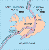
- Iceland offers scientists a natural
laboratory for studying the processes that occur along submerged parts of a
divergent boundary. Iceland formed less than 70 million years ago from magma
rising through the rift in the Mid-Atlantic Ridge.
- While the creation of new crust adds mass
to Iceland on both sides of the boundary, it also creates a rift along the
boundary. Iceland will inevitably break apart into two separate land masses
at some point in the future, as the Atlantic waters eventually rush in to
fill the widening and deepening space between.

Transform fault boundaries
- The zone between two plates sliding horizontally past one another is
called a transform-fault boundary, or simply a transform boundary. These
boundaries, like the San Andreas fault in California, are marked by strong
earthquakes.
- Most transform faults are found on the ocean floor. They commonly offset
the active spreading ridges, producing zig-zag plate margins, and are
generally defined by shallow earthquakes. A few occur on land, as in the
case of the San Andreas fault in California.
Hot spots
- When fountains of magma from the core erupt through the crust as the
tectonic plates drift over them, volcanic 'trails' can form. This is
precisely how the Hawaiian islands are believed to have formed.

Himalayas
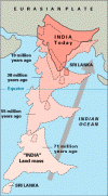
- The Himalayas were formed when the Indian
plate collided into the Eurasian plate about 45 million years ago. Since
the Indian Plate and the Eurasian Plate are both continental plates, and
thus have the same density, neither was subducted. Instead, both plates
pushed upwards, creating the Himalayan mountain range.
- Before the collision, the northward speed of the Indian plate was 15-20
cm/year; afterward, the plate slowed to around 5 cm/year as it advanced
roughly 2000 km into the Eurasian plate. Today, the Indian plate is still
moving north, at 2 cm/year, and the Himalayas are still rising.
- The world's 10 highest mountains (e.g., Mt. Everest) are currently in
the Himalayas, but the Andes are going up faster and some of their peaks may
well outgrow those in the Himalayas some day.

Rift valleys
- Currently in the northeast section of Africa is a good example of a
divergent boundary system. Here rising magma rises upward, causing cracks in
the rigid lithosphere. As the cracks pull apart, large slabs of rock sink,
creating a rift zone. More spreading creates a narrow sea, like the Red Sea,
and eventually a expansive ocean basin and a ridge system like the Atlantic
Ocean.
Rocky Mountains
- The Rocky Mountains represent the subduction
and collision of an old oceanic plate with the west coast of North America.
- The growth of the Rocky Mountains (also known as Laramide orogeny) has
been one of the most perplexing of geologic puzzles. Normally, mountain
building is focused 200-400 miles inland from a subduction zone boundary.
The Rockies, on the other hand, are hundreds of miles farther inland. What
geologic processes raise mountains at this scale?
- Although geologists continue to gather evidence to explain the rise of
the Rockies, the answer most likely lies with an unusually flat angle of
subducting slab. The relatively shallow angle of subduction caused the focus
of melting and deformation (i.e., mountain building) to extend much
farther inland and over a broader area than is normally expected.

Rock cycle

Return to class notes TOC.
Page last modified:


